Wednesday, December 31, 2014

January 2015 outlook


  It was a temperature sandwich. The first three days of December were cold, then temps rebounded nicely. Around mid-month we hit 50 or warmer on three consecutive days! We ended the month with another cold snap.  Our warmest temperature in the Twin Cities was 51 degrees, on December 13 and 15. The coldest reading was 7 below zero on December 30 and 31.  The average temperature for the month of December was 4.6 degrees above normal in the Twin Cities. Our official snowfall total at MSP airport was 5.6 inches.
   
  2014 has ended, and the Minnesota State Climatology Office has a nice feature about the top weather events of the year. Check it out at 2014 Weather Top 5
 
  Looking ahead, the January temperature outlook from the Climate Prediction Center of the National Weather Service shows a slight tendency for below normal temperatures over Minnesota and western Wisconsin:

  The outlook doesn’t mean that every day is expected to be cooler than normal…it is the average temp for the entire month that shows a slight cooler-than-normal tendency. In case you’re wondering, our average high in the Twin Cities doesn’t move much during January…it is 24 degrees on January 1st and 25 degrees on January 31st.

  I’m on Twitter: @RonTrenda and LinkedIn: http://www.linkedin.com/in/rontrenda

Sunday, November 30, 2014

December outlook


   We enjoyed some mild weather during the first week of November, topping 50 degrees on three days in the Twin Cities. Then the weather pattern changed, and we saw only two days with above normal temperatures during the rest of the month. Our warmest temperature in the Twin Cities was 56 degrees, on November 2nd, and our coldest reading was 4 below zero on the 27th. The average temperature for the month of November was 8.3 degrees below normal in the Twin Cities. Snow arrived on the 10th, with 3.4 inches at MSP airport and much higher amounts over central Minnesota. Our November tally at MSP airport was 9.4 inches. 

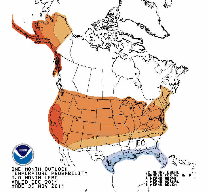
  Looking ahead, the December temperature outlook from the Climate Prediction Center of the National Weather Service shows a tendency for above normal temperatures over Minnesota and Wisconsin:


   Since December will start out cold, temps will have to rebound substantially for our average December temp to rise above normal. In case you’re wondering, our average high in the Twin Cities drops from 32 degrees on December 1st to 24 degrees on December 31st.

  I’m on Twitter: @RonTrenda and LinkedIn: http://www.linkedin.com/in/rontrenda

Saturday, November 15, 2014

Game changer


  It was a nice start to November, with several days of above-normal temperatures. Snow arrived on the 10th, with 3.4 inches at MSP airport and much higher amounts over central Minnesota. Snowcover and a cold upper air flow pattern have combined to give us several days of frigid temperatures. Since November 10th, our temps have been more typical of January than November.
  Any hope for a nice rebound in temps? Not anytime soon. Chilly temperatures persist through the 5 day forecast, which takes us to November 19th.  Looking further ahead, the 6-10 day temperature outlook (Nov 20-24) from the Climate Prediction Center of the National Weather Service shows a tendency for below normal temperatures over Minnesota and Wisconsin:

  In case you’re wondering, our average high in the Twin Cities drops from 41 degrees on November 15th to 33 degrees on November 30th.
  
  I’m on Twitter: @RonTrenda and LinkedIn: http://www.linkedin.com/in/rontrenda

Friday, October 31, 2014

November outlook


   It was an awesome October. We enjoyed plenty of sunshine, and gorgeous fall colors lingered until the end of the month. In the Twin Cities, we measured only 1.75 inches of rain, with only 28/100ths of an inch after October 2nd. Our warmest temperature was 72 degrees, on October 16th, and our coldest reading was 26 degrees on the 31st. The Twin Cities average temperature for the month of October was very slightly (3/10ths of a degree) above normal. 
  
  Looking ahead, the November temperature outlook from the Climate Prediction Center of the National Weather Service shows a slight tendency for above normal temperatures over Minnesota and northern Wisconsin:


   The outlook doesn’t mean that every day is expected to be warmer than normal…it is the average temp for the entire month that shows a slight warmer-than-normal tendency.  In case you’re wondering, our average high in the Twin Cities drops from 50 degrees on November 1st to 33 degrees on November 30th.
  
   I’m on Twitter: @RonTrenda and LinkedIn: http://www.linkedin.com/in/rontrenda 

Tuesday, October 14, 2014

Beautiful


There are some great fall colors at the Minnesota Landscape Arboretum in Chanhassen right now. Here are a few photos taken this afternoon:

Big picture


Pick a color


Don't forget to look up!


Tuesday, September 30, 2014

October outlook

  Our September started out pleasantly warm, then it turned downright nippy….highs in the Twin Cities were only in the 50s and 60s from September 10th through the 16th. Temperatures recovered nicely from that dip, with highs mostly in the mid 70s to lower 80s from September 17th through the 28th. Our warmest temperature was 86 degrees, on September 4th, and our coldest reading was 39 degrees on the 13th. Our average temperature for the month of September was 7/10ths of a degree above normal in the Twin Cities. 

  Looking ahead, the October temperature outlook from the Climate Prediction Center of the National Weather Service shows a tendency for below normal temperatures over Minnesota and Wisconsin:


  The outlook doesn’t mean that every day is expected to be cooler than normal…it is the average temp for the entire month that shows a cool tendency.  In case you’re wondering, our average high in the Twin Cities drops from 65 degrees on October 1st to 51 degrees on October 31st.
  
  I’m on Twitter: @RonTrenda and LinkedIn: http://www.linkedin.com/in/rontrenda

Sunday, August 31, 2014

September outlook


  We had some warm and muggy days in August, but it also felt like autumn at times, with cool temps and low humidity.  In the Twin Cities, this was our first August without a temperature of 90 degrees or warmer since 2011. Our warmest temperature was 89 degrees, on the 24th, and our coldest reading was 56 degrees on August 25th.  The average temperature for the month of August was 2.1 degrees above normal in the Twin Cities.  August rainfall at MSP airport was 2.90 inches, about 1.40 inches below normal.
 
  Looking ahead, the September temperature outlook from the Climate Prediction Center of the National Weather Service doesn’t show a tendency for either below normal or above normal temperatures over Minnesota and Wisconsin:


  In case you are wondering, our average high in the Twin Cities drops from 77 degrees on September 1st to 65 degrees on September 30th.


  I’m on Twitter: @RonTrenda and LinkedIn: http://www.linkedin.com/in/rontrenda

Thursday, July 31, 2014

August outlook

  After a very soggy June, many people were hoping for some drier weather in July.  Their wishes were granted. Our July rainfall total at MSP airport was only 2.27 inches, which is 1.77 inches below normal. July was only one-fifth as wet as June! That’s an impressive change of pace. The average monthly temperature for July was 2.3 degrees below normal in the Twin Cities. Our warmest temperature was 92 degrees, on July 21st, and our coldest reading was 54 degrees on July 2nd and July 15th.  
  Looking ahead, the August temperature outlook from the Climate Prediction Center of the National Weather Service shows a tendency for below normal temperatures over Minnesota and Wisconsin:

The outlook doesn’t mean that every day is expected to be cooler than normal…it is the average temp for the entire month that shows a cool tendency.  A little bit cool can be okay in August…our average high in the Twin Cities drops slowly from 83 degrees on August 1st to 78 degrees on August 31st.
  
   I’m on Twitter: @RonTrenda and LinkedIn: http://www.linkedin.com/in/rontrenda


Monday, June 30, 2014

July outlook

   Stating the obvious, June was wet. We totaled 11.36 inches of rain in the Twin Cities. That’s about seven inches more than our typical June! Lake and river levels have risen and creeks are running very high. Our rainfall total was less than a third of an inch shy of the Twin Cities June record of 11.67 inches, set in 1874. The average monthly temperature for June was slightly above normal, ending our streak of cooler than normal months at seven. Our warmest reading was 85 degrees, on June 16th, 20th, 21st and 29th, and our coldest reading was 49 on the 8th.  
  Looking ahead, the July temperature outlook from the Climate Prediction Center of the National Weather Service shows a slight tendency for below normal temperatures over much of Minnesota and western Wisconsin:  


  The outlook doesn’t mean that every day is expected to be cooler than normal…it is the average temp for the entire month that shows a slight cool tendency.  A little bit cool can be okay in July…our average high in the Twin Cities is listed as either 83 or 84 degrees for each day of the month.
  
   I’m on Twitter: @RonTrenda and LinkedIn: http://www.linkedin.com/in/rontrenda
 

Saturday, May 31, 2014

  May started out very cold, but temperatures rebounded nicely during the final week of the month.  Our average monthly temperature for May was half of a degree below normal in the Twin Cities, making it our seventh consecutive month with colder than normal temperatures.  Our warmest reading was 87 degrees on the 30th, and our coldest was 36 on the 4th.  We totaled 4.55 inches of rain, which is 1.19 inches above average.
  Looking ahead, the temperature outlook from the Climate Prediction Center of the National Weather Service shows a tendency for below normal temperatures over Minnesota and Wisconsin:

  The outlook doesn’t mean that every day is expected to be cooler than normal…it is the average temp for the entire month that shows a cool tendency.  A little bit cool can be okay in June…our average high in the Twin Cities rises from 74 degrees on June 1st to 83 degrees on June 30th.    
   
  I’m on Twitter: @RonTrenda and LinkedIn: http://www.linkedin.com/in/rontrenda

Wednesday, April 30, 2014

May outlook

   April ended with a string of soggy, windy days. The last nine days of the month were cooler than normal the Twin Cities. We’re ready for some sunshine and warmth!
  Our average monthly temperature for April was 4.8 degrees below normal in the Twin Cities. This marks our sixth consecutive month with colder than normal temperatures.  Our lowest temp was 18 on the 15th, and our warmest reading was 74 degrees on the 20th.
   We witnessed the second wettest April in Twin Cities history, with 6.27 inches of precipitation (rain plus the water content of our snow).  We tallied 7 inches of snow, with 6.5 inches falling on April 3-4. Our snowfall total for the 2013-2014 snow season stands at an impressive 69.8 inches
   Looking ahead, the May temperature outlook from the Climate Prediction Center of the National Weather Service shows a tendency for below normal temperatures over Minnesota and Wisconsin:

   The outlook doesn’t mean that every day is expected to be cooler than normal…it is the average temp for the entire month that shows a cool tendency.  Cool can be okay in May…our average high in the Twin Cities rises from 65 degrees on May 1st to 74 degrees on May 31st.    
   
   I’m on Twitter: @RonTrenda and LinkedIn: http://www.linkedin.com/in/rontrenda

Monday, March 31, 2014

April outlook

   This is more like it! The mounds of snow on the lawn have melted, and we no longer have to shuffle along icy sidewalks. Potholes are still a nuisance, but we’re told that our best road crews are working on the problem…I sure hope so.
   We’ve earned our spring this year. Our average monthly temperature for March was 7.3 degrees below normal in the Twin Cities. This marks our fifth consecutive month with colder than normal temperatures. We saw below-zero low temps on 3 days during March, and our coldest reading in the Twin Cities was 15 below zero on the 2nd.  High temperatures topped 32 degrees on only 17 days, with our warmest reading of 60 degrees occurring on March 30th.  
   We tallied only 4.7 inches of snow this March. That’s well below our average March snowfall total of 10.2 inches. Our biggest daily snowfall total was 2.3 inches, on the 18th, and we had measurable snow on only 6 days. Even without any major March snowstorm in the Twin Cities, our snowfall total for the 2013-2014 snow season stands at an impressive 62.8 inches
   Looking ahead, the April temperature outlook from the Climate Prediction Center of the National Weather Service shows a tendency for below normal temperatures over Minnesota and Wisconsin:


   The outlook doesn’t mean that every day is expected to be cooler than normal…it is the average temp for the entire month that shows a cool tendency.  Cool can be okay in April…our average high in the Twin Cities rises from 50 degrees on April 1st to 65 degrees on April 30th.    
   
   I’m on Twitter: @RonTrenda and LinkedIn: http://www.linkedin.com/in/rontrenda

Friday, February 28, 2014

March outlook

   It has to get warmer. The snow will melt and we’ll be golfing by the third week in April…at least that’s what usually happens around here.
   February 2014 was snowier and much colder than normal in the Twin Cities. Our biggest snowfall, from February 20th into the early hours of the 21st, dumped 9.9 inches of wet snow at MSP airport. The snow was followed by plummeting temps, which led to ice-covered roads and white-knuckle commutes. Our snowfall total for the month was 18.4 inches, about 10 inches above normal.
   It was a very cold February, with an average monthly temp about 12 degrees below normal. We had below-zero low temps on 16 days, and saw our coldest reading of 14 below zero on the 27th.  Our temp only topped 32 degrees on 3 days, with our warmest temp of 44 degrees on the 18th.
   February was preceded by extremely cold temps in January and December. As a result, Twin Citians endured the coldest December through February (meteorological winter) in 35 years!
   Looking ahead, the March temperature outlook from the Climate Prediction Center of the National Weather Service shows a strong tendency for below normal temperatures over MN and WI:

   The outlook doesn’t mean that every day is expected to be cooler than normal…it is the average temp for the entire month that is likely to be below normal.    
   
    I’m on Twitter: @RonTrenda and LinkedIn: http://www.linkedin.com/in/rontrenda

Friday, January 31, 2014

February outlook


  January 2014 was a character builder. In the Twin Cities, our average temperature for the entire month was 7.6 degrees below normal, and we saw measurable snow on 13 days. Our snowfall total at MSP airport was 22.7 inches, making it the snowiest January since we shoveled 33.1 inches back in 1999. We made the top ten…January 2014 ranks as the seventh snowiest January in Twin Cities history, based on records going back to 1885.
  We had only 8 days with high temps above 32 degrees, and we endured some memorably cold nights….below zero low temps were recorded on 20 days! Our warmest temp was 40 degrees on January 12th, and our coldest temp was 23 below zero on January 6th. Our high temperature on the 6th struggled to reach 12 below zero! I hope we find that fact amusing in a few months.
  Looking ahead, the February temperature outlook from the Climate Prediction Center of the National Weather Service shows a strong tendency for below normal temperatures over Minnesota and Wisconsin:


  The outlook doesn’t mean that every day in February will be unusually cold, but the average temp for the entire month is likely to be below normal.    
   
  I’m on Twitter: @RonTrenda and LinkedIn: http://www.linkedin.com/in/rontrenda