Wednesday, April 30, 2014

May outlook

   April ended with a string of soggy, windy days. The last nine days of the month were cooler than normal the Twin Cities. We’re ready for some sunshine and warmth!
  Our average monthly temperature for April was 4.8 degrees below normal in the Twin Cities. This marks our sixth consecutive month with colder than normal temperatures.  Our lowest temp was 18 on the 15th, and our warmest reading was 74 degrees on the 20th.
   We witnessed the second wettest April in Twin Cities history, with 6.27 inches of precipitation (rain plus the water content of our snow).  We tallied 7 inches of snow, with 6.5 inches falling on April 3-4. Our snowfall total for the 2013-2014 snow season stands at an impressive 69.8 inches
   Looking ahead, the May temperature outlook from the Climate Prediction Center of the National Weather Service shows a tendency for below normal temperatures over Minnesota and Wisconsin:

   The outlook doesn’t mean that every day is expected to be cooler than normal…it is the average temp for the entire month that shows a cool tendency.  Cool can be okay in May…our average high in the Twin Cities rises from 65 degrees on May 1st to 74 degrees on May 31st.    
   
   I’m on Twitter: @RonTrenda and LinkedIn: http://www.linkedin.com/in/rontrenda

Monday, March 31, 2014

April outlook

   This is more like it! The mounds of snow on the lawn have melted, and we no longer have to shuffle along icy sidewalks. Potholes are still a nuisance, but we’re told that our best road crews are working on the problem…I sure hope so.
   We’ve earned our spring this year. Our average monthly temperature for March was 7.3 degrees below normal in the Twin Cities. This marks our fifth consecutive month with colder than normal temperatures. We saw below-zero low temps on 3 days during March, and our coldest reading in the Twin Cities was 15 below zero on the 2nd.  High temperatures topped 32 degrees on only 17 days, with our warmest reading of 60 degrees occurring on March 30th.  
   We tallied only 4.7 inches of snow this March. That’s well below our average March snowfall total of 10.2 inches. Our biggest daily snowfall total was 2.3 inches, on the 18th, and we had measurable snow on only 6 days. Even without any major March snowstorm in the Twin Cities, our snowfall total for the 2013-2014 snow season stands at an impressive 62.8 inches
   Looking ahead, the April temperature outlook from the Climate Prediction Center of the National Weather Service shows a tendency for below normal temperatures over Minnesota and Wisconsin:


   The outlook doesn’t mean that every day is expected to be cooler than normal…it is the average temp for the entire month that shows a cool tendency.  Cool can be okay in April…our average high in the Twin Cities rises from 50 degrees on April 1st to 65 degrees on April 30th.    
   
   I’m on Twitter: @RonTrenda and LinkedIn: http://www.linkedin.com/in/rontrenda

Friday, February 28, 2014

March outlook

   It has to get warmer. The snow will melt and we’ll be golfing by the third week in April…at least that’s what usually happens around here.
   February 2014 was snowier and much colder than normal in the Twin Cities. Our biggest snowfall, from February 20th into the early hours of the 21st, dumped 9.9 inches of wet snow at MSP airport. The snow was followed by plummeting temps, which led to ice-covered roads and white-knuckle commutes. Our snowfall total for the month was 18.4 inches, about 10 inches above normal.
   It was a very cold February, with an average monthly temp about 12 degrees below normal. We had below-zero low temps on 16 days, and saw our coldest reading of 14 below zero on the 27th.  Our temp only topped 32 degrees on 3 days, with our warmest temp of 44 degrees on the 18th.
   February was preceded by extremely cold temps in January and December. As a result, Twin Citians endured the coldest December through February (meteorological winter) in 35 years!
   Looking ahead, the March temperature outlook from the Climate Prediction Center of the National Weather Service shows a strong tendency for below normal temperatures over MN and WI:

   The outlook doesn’t mean that every day is expected to be cooler than normal…it is the average temp for the entire month that is likely to be below normal.    
   
    I’m on Twitter: @RonTrenda and LinkedIn: http://www.linkedin.com/in/rontrenda

Friday, January 31, 2014

February outlook


  January 2014 was a character builder. In the Twin Cities, our average temperature for the entire month was 7.6 degrees below normal, and we saw measurable snow on 13 days. Our snowfall total at MSP airport was 22.7 inches, making it the snowiest January since we shoveled 33.1 inches back in 1999. We made the top ten…January 2014 ranks as the seventh snowiest January in Twin Cities history, based on records going back to 1885.
  We had only 8 days with high temps above 32 degrees, and we endured some memorably cold nights….below zero low temps were recorded on 20 days! Our warmest temp was 40 degrees on January 12th, and our coldest temp was 23 below zero on January 6th. Our high temperature on the 6th struggled to reach 12 below zero! I hope we find that fact amusing in a few months.
  Looking ahead, the February temperature outlook from the Climate Prediction Center of the National Weather Service shows a strong tendency for below normal temperatures over Minnesota and Wisconsin:


  The outlook doesn’t mean that every day in February will be unusually cold, but the average temp for the entire month is likely to be below normal.    
   
  I’m on Twitter: @RonTrenda and LinkedIn: http://www.linkedin.com/in/rontrenda


Tuesday, December 31, 2013

January outlook

  December 2013 was wintry, to say the least. Our average temperature for the month was 7.3 degrees below normal in the Twin Cities, and we saw measurable snow on 15 days! Our snowfall total was an impressive 15.9 inches.    
  We had only 7 days with high temps above 32 degrees. Our warmest high temp was 47 degrees on December 28th, and our coldest low temp was 13 below zero on Christmas Eve.
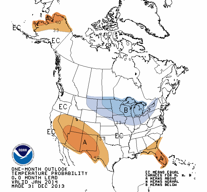
    Looking ahead, the January temperature outlook from the Climate Prediction Center of the National Weather Service shows a tendency toward below normal temperatures over Minnesota and Wisconsin:


  The outlook doesn’t mean that every day is expected to be cooler than normal…it is the average temp for the entire month that shows a cool tendency.
      
  Hope you have a happy 2014!

  I’m on Twitter: @RonTrenda and LinkedIn: http://www.linkedin.com/in/rontrenda

Thursday, October 31, 2013

November outlook

  October started out really nice, with plenty of sunshine and temperatures well above normal. In the Twin Cities, we enjoyed highs in the 70s on 6 of the first 11 days. Our warmest day was October 10th, with a high of 78 degrees. The second half of October featured much cooler weather. We saw highs in the 40s on 7 days, and the high was only 39 degrees on October 23! The warm start and cool finish resulted in an average temperature for October 2013 that was very near normal…just two-tenths of a degree above normal.
  Looking ahead, the November outlook from the Climate Prediction Center of the National Weather Service doesn’t show a tendency for either above-normal or below normal temperatures over Minnesota and Wisconsin:


  In case you’re wondering, our average high in the Twin Cities is 50 on November 1, dropping to 33 by November 30. Hope you have a great month!
  I’m on Twitter: @RonTrenda and LinkedIn: http://www.linkedin.com/in/rontrenda 

Monday, September 30, 2013

October outlook

  September was a month of some wild temperature swings. High temperatures in the Twin Cities ranged from 94 degrees on September 7 and September 9 to a chilly high of 64 degrees on September 21.  We had 6 days with highs in the 60s and 14 days with highs in the 70s. We also saw 7 days with highs in the 80s and 3 days with highs in the 90s. For the entire month, we came in about 5 degrees above normal.

  Looking ahead, the October outlook from the Climate Prediction Center of the National Weather Service shows a tendency for above-normal temperatures over Minnesota and Wisconsin:


  The outlook doesn’t mean that you should expect above-normal temperatures every day…it is the average temp for the entire month that shows a tendency to come in warmer than normal.  In case you’re wondering, our average high in the Twin Cities is 65 on October 1, dropping to 51 by October 31. Hope you have a great month!
  
I’m on Twitter: @RonTrenda and LinkedIn: http://www.linkedin.com/in/rontrenda